


11

Science
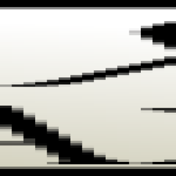
Circuit Simulator 2019Analogic circuit simulatorOP/AC/DC/TRAN/DISTO/NOISE/FFT/FOUR/TFTEMPERATURE SWEEPDynamic Operating Point *Dynamic TRAN * Dynamic AC *** Values of Voltage and Current are displayed on the schematic in real-time.For TRAN you had to select the tstart tstop tstep and clicking...
Arch (tar.gz)
Available as/for:64bit - x86Arch (tar.gz)stable
5 comments
5.0
12

Science
by hb882
extrema is a powerful visualization and data analysis tool that enables researchers to quickly distill their large, complex data sets into meaningful information. Its flexibility, sophistication, and power allow you to easily develop your own commands and create highly customized graphs. NOTE:...
Available as/for:64bit - x86git
5.0
13

Science
by hafmed
water hammer simulation
AppImageWindows Binary
Available as/for:64bit - x86AppImageDesktopPhonestableTabletWindows Binary
5.0
14

Science
by hafmed
hydraulics open channel Gradually-Varied Flow (GVF) simulation.
AppImageWindows Binary
Available as/for:64bit - x86AppImageDesktopPhonestableTabletWindows Binary
5.0
15

Science
by hafmed
basic numerical Methods for engineers.A practical tool to foresee the result of calculus exercises. -Compute roots of nonlinear equations ; -Solving systems of linear equations ; -Polynomial approximation calculator ; -Calculate numerical integral ; -Solve first order ordinary...
AppImageWindows Binary
Available as/for:64bit - x86AppImageDesktopPhonestableTabletWindows Binary
5.0
16

Science
by virtualmeet
MathMod is an open source (GPL) mathematical software developed by Abderrahman Taha.It's used to model, plot and animate 3D/4D parametric and implicit surfaces.
OS-X compatibleSource-CodeWindows Binary
Available as/for:32bit - x8664bit - x86arm64 - 64bitarmhf - 32bitDesktopOS-X compatibleSource-CodestableWindows Binary
5.0
17

Science
by kiozen
QMapShack is a consumer grade software to work with data aquired by GPS devices. The data can be displayed on a variety of maps and stored in a database. Additionally new data can be created to plan tours.Maps: Garmin vector maps and *.jnx raster maps Raster maps supported by GDAL GEMF...
Source-Code
Available as/for:gitSource-Codestable
8 comments
7.0
Plings 1
19

Science
by hb882
Multi-platform software for record, demodulate, decode and process data from weather satellites.NOTE: This is only to provide appimages, I am not the developer.
AppImage
Available as/for:64bit - x86AppImage
5.0
20

Science
by hb882
Tablexplore is an application for data analysis and plotting built in Python using the PySide2/Qt toolkit. It uses the pandas DataFrame class to store the table data. Pandas is an open source Python library providing high-performance data structures and data analysis tools.NOTE: This is only to...
AppImage
Available as/for:64bit - x86AppImage
5.0


Makhber
Science
Could you please remove this app, I maintain it at https://www.pling.com/p/2009651/
mchinoune